
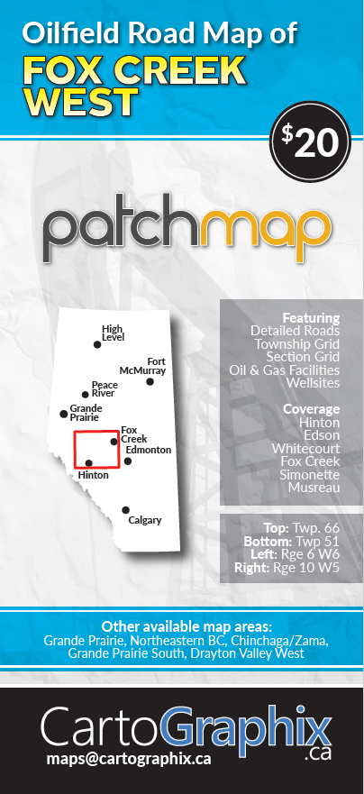
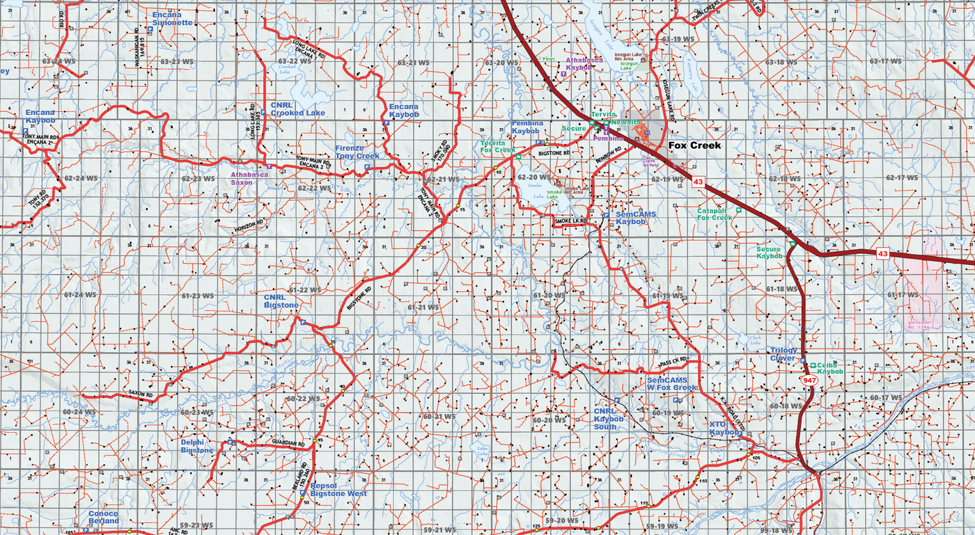
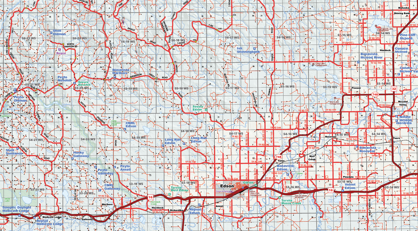
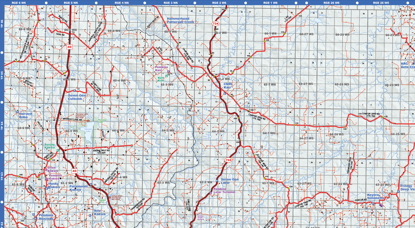
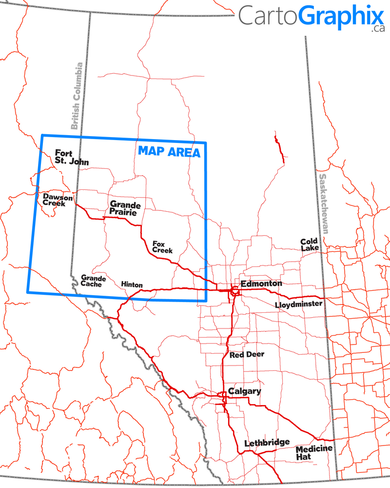
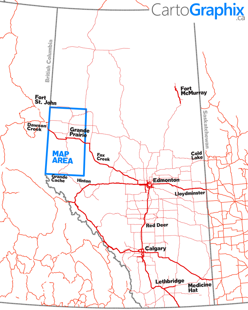
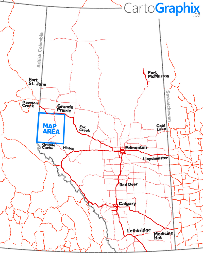
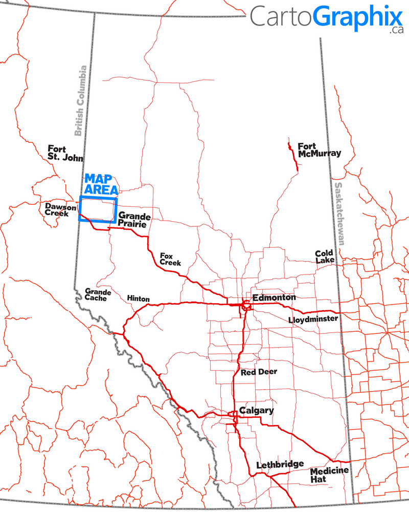
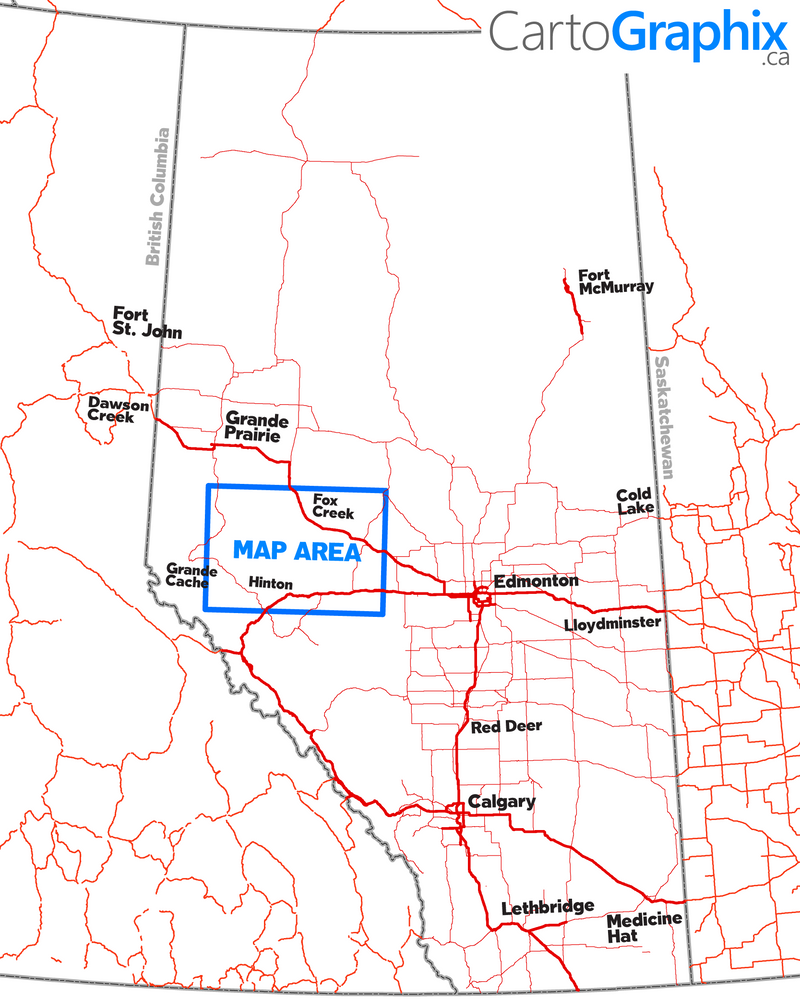
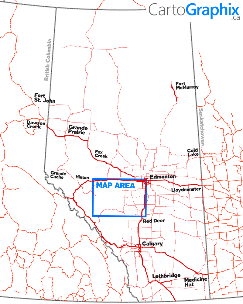
{"id":4558799306867,"title":"Fox Creek West Oilfield Road Map (Folded) - 4\"W x 9\"H","handle":"fox-creek-west-oilfield-road-map-folded-4w-x-9h","description":"\u003ch3\u003e\u003cstrong\u003e \u003c\/strong\u003e\u003c\/h3\u003e\n\u003cp\u003eFeatures accurate PatchMap™ oilfield roads, labeled gas and waste plants, wellsites, compressor stations, road kilometer posts and radio frequencies, township grid with sections, detailed streams and waterbodies, parks and protected areas, First Nations reserves\/ Metis settlements, and relief-shade background.\u003c\/p\u003e\n\u003cdiv\u003e\u003cspan\u003e\u003cstrong\u003e Map Extents:\u003c\/strong\u003e\u003c\/span\u003e\u003c\/div\u003e\n\u003cdiv\u003e\u003cspan\u003e\u003cstrong\u003e Left: \u003c\/strong\u003e Highway 40 (Rge 6 W6M)\u003c\/span\u003e\u003c\/div\u003e\n\u003cdiv\u003e\u003cspan\u003e\u003cstrong\u003e Right:\u003c\/strong\u003e Swan Hills (Rge 10 W5M)\u003c\/span\u003e\u003c\/div\u003e\n\u003cdiv\u003e\u003cspan\u003e\u003cstrong\u003e Bottom:\u003c\/strong\u003e Hinton (Twp 51)\u003c\/span\u003e\u003c\/div\u003e\n\u003cdiv\u003e\u003cspan\u003e\u003cstrong\u003e Top:\u003c\/strong\u003e Hwy 43\/Simonette Road Turn-off (Twp 66)\u003c\/span\u003e\u003c\/div\u003e\n\u003cp\u003e \u003c\/p\u003e\n\u003cdiv\u003e\u003cspan\u003e\u003cstrong\u003e Folded Size:\u003c\/strong\u003e 4\"W x 9\"H\u003c\/span\u003e\u003c\/div\u003e\n\u003cdiv\u003e\u003cspan\u003e\u003cstrong\u003e Unfolded Size:\u003c\/strong\u003e 39\"W x 27\"H\u003c\/span\u003e\u003c\/div\u003e\n\u003cdiv\u003e\u003cspan\u003e \u003c\/span\u003e\u003c\/div\u003e\n\u003cdiv\u003e\u003cspan\u003eThis map is single-sided and printed on high-quality bond paper\u003c\/span\u003e\u003c\/div\u003e\n\u003cp\u003e\u003cbr\u003e\u003cspan\u003eManufacturer: \u003cb\u003eCartoGraphix\u003c\/b\u003e\u003c\/span\u003e\u003c\/p\u003e\n\u003cp\u003e \u003c\/p\u003e","published_at":"2020-07-27T13:30:19-06:00","created_at":"2020-07-27T13:30:20-06:00","vendor":"CartoGraphix","type":"map","tags":[],"price":2000,"price_min":2000,"price_max":2000,"available":true,"price_varies":false,"compare_at_price":null,"compare_at_price_min":0,"compare_at_price_max":0,"compare_at_price_varies":false,"variants":[{"id":31940832100467,"title":"Default Title","option1":"Default Title","option2":null,"option3":null,"sku":"","requires_shipping":true,"taxable":true,"featured_image":null,"available":true,"name":"Fox Creek West Oilfield Road Map (Folded) - 4\"W x 9\"H","public_title":null,"options":["Default Title"],"price":2000,"weight":0,"compare_at_price":null,"inventory_quantity":-14,"inventory_management":null,"inventory_policy":"deny","barcode":"","requires_selling_plan":false,"selling_plan_allocations":[]}],"images":["\/\/www.skybase.ca\/cdn\/shop\/products\/Fox_Creek_West.png?v=1595878302","\/\/www.skybase.ca\/cdn\/shop\/products\/Fox_Creek_West_Map_1.png?v=1595878302","\/\/www.skybase.ca\/cdn\/shop\/products\/Fox_Creek_West_Map_3.png?v=1595878301","\/\/www.skybase.ca\/cdn\/shop\/products\/Fox_Creek_West_Map_2.png?v=1595878302"],"featured_image":"\/\/www.skybase.ca\/cdn\/shop\/products\/Fox_Creek_West.png?v=1595878302","options":["Title"],"media":[{"alt":null,"id":7084913786995,"position":1,"preview_image":{"aspect_ratio":0.459,"height":881,"width":404,"src":"\/\/www.skybase.ca\/cdn\/shop\/products\/Fox_Creek_West.png?v=1595878302"},"aspect_ratio":0.459,"height":881,"media_type":"image","src":"\/\/www.skybase.ca\/cdn\/shop\/products\/Fox_Creek_West.png?v=1595878302","width":404},{"alt":null,"id":7084913754227,"position":2,"preview_image":{"aspect_ratio":1.82,"height":1019,"width":1855,"src":"\/\/www.skybase.ca\/cdn\/shop\/products\/Fox_Creek_West_Map_1.png?v=1595878302"},"aspect_ratio":1.82,"height":1019,"media_type":"image","src":"\/\/www.skybase.ca\/cdn\/shop\/products\/Fox_Creek_West_Map_1.png?v=1595878302","width":1855},{"alt":null,"id":7084913819763,"position":3,"preview_image":{"aspect_ratio":1.81,"height":1018,"width":1843,"src":"\/\/www.skybase.ca\/cdn\/shop\/products\/Fox_Creek_West_Map_3.png?v=1595878301"},"aspect_ratio":1.81,"height":1018,"media_type":"image","src":"\/\/www.skybase.ca\/cdn\/shop\/products\/Fox_Creek_West_Map_3.png?v=1595878301","width":1843},{"alt":null,"id":7084913852531,"position":4,"preview_image":{"aspect_ratio":1.817,"height":1018,"width":1850,"src":"\/\/www.skybase.ca\/cdn\/shop\/products\/Fox_Creek_West_Map_2.png?v=1595878302"},"aspect_ratio":1.817,"height":1018,"media_type":"image","src":"\/\/www.skybase.ca\/cdn\/shop\/products\/Fox_Creek_West_Map_2.png?v=1595878302","width":1850}],"requires_selling_plan":false,"selling_plan_groups":[],"content":"\u003ch3\u003e\u003cstrong\u003e \u003c\/strong\u003e\u003c\/h3\u003e\n\u003cp\u003eFeatures accurate PatchMap™ oilfield roads, labeled gas and waste plants, wellsites, compressor stations, road kilometer posts and radio frequencies, township grid with sections, detailed streams and waterbodies, parks and protected areas, First Nations reserves\/ Metis settlements, and relief-shade background.\u003c\/p\u003e\n\u003cdiv\u003e\u003cspan\u003e\u003cstrong\u003e Map Extents:\u003c\/strong\u003e\u003c\/span\u003e\u003c\/div\u003e\n\u003cdiv\u003e\u003cspan\u003e\u003cstrong\u003e Left: \u003c\/strong\u003e Highway 40 (Rge 6 W6M)\u003c\/span\u003e\u003c\/div\u003e\n\u003cdiv\u003e\u003cspan\u003e\u003cstrong\u003e Right:\u003c\/strong\u003e Swan Hills (Rge 10 W5M)\u003c\/span\u003e\u003c\/div\u003e\n\u003cdiv\u003e\u003cspan\u003e\u003cstrong\u003e Bottom:\u003c\/strong\u003e Hinton (Twp 51)\u003c\/span\u003e\u003c\/div\u003e\n\u003cdiv\u003e\u003cspan\u003e\u003cstrong\u003e Top:\u003c\/strong\u003e Hwy 43\/Simonette Road Turn-off (Twp 66)\u003c\/span\u003e\u003c\/div\u003e\n\u003cp\u003e \u003c\/p\u003e\n\u003cdiv\u003e\u003cspan\u003e\u003cstrong\u003e Folded Size:\u003c\/strong\u003e 4\"W x 9\"H\u003c\/span\u003e\u003c\/div\u003e\n\u003cdiv\u003e\u003cspan\u003e\u003cstrong\u003e Unfolded Size:\u003c\/strong\u003e 39\"W x 27\"H\u003c\/span\u003e\u003c\/div\u003e\n\u003cdiv\u003e\u003cspan\u003e \u003c\/span\u003e\u003c\/div\u003e\n\u003cdiv\u003e\u003cspan\u003eThis map is single-sided and printed on high-quality bond paper\u003c\/span\u003e\u003c\/div\u003e\n\u003cp\u003e\u003cbr\u003e\u003cspan\u003eManufacturer: \u003cb\u003eCartoGraphix\u003c\/b\u003e\u003c\/span\u003e\u003c\/p\u003e\n\u003cp\u003e \u003c\/p\u003e"}
Call us at 780-814-2130 to Book a Meeting or Online Demo
780-814-2130 | sales@skybase.ca
Robert Coutts – Founder / CEO
After Hours / Weekends
mobile: 780-518-2666
rc@skybase.ca
Calgary AB - 587.287.1867
Saskatoon SK - 306.500.0995
Victoria BC - 778.402.3967
Keep in Touch
Sign up for our newsletter and be the first to know about coupons and special promotions.
© 2024 Skybase Geomatic Solutions Inc.