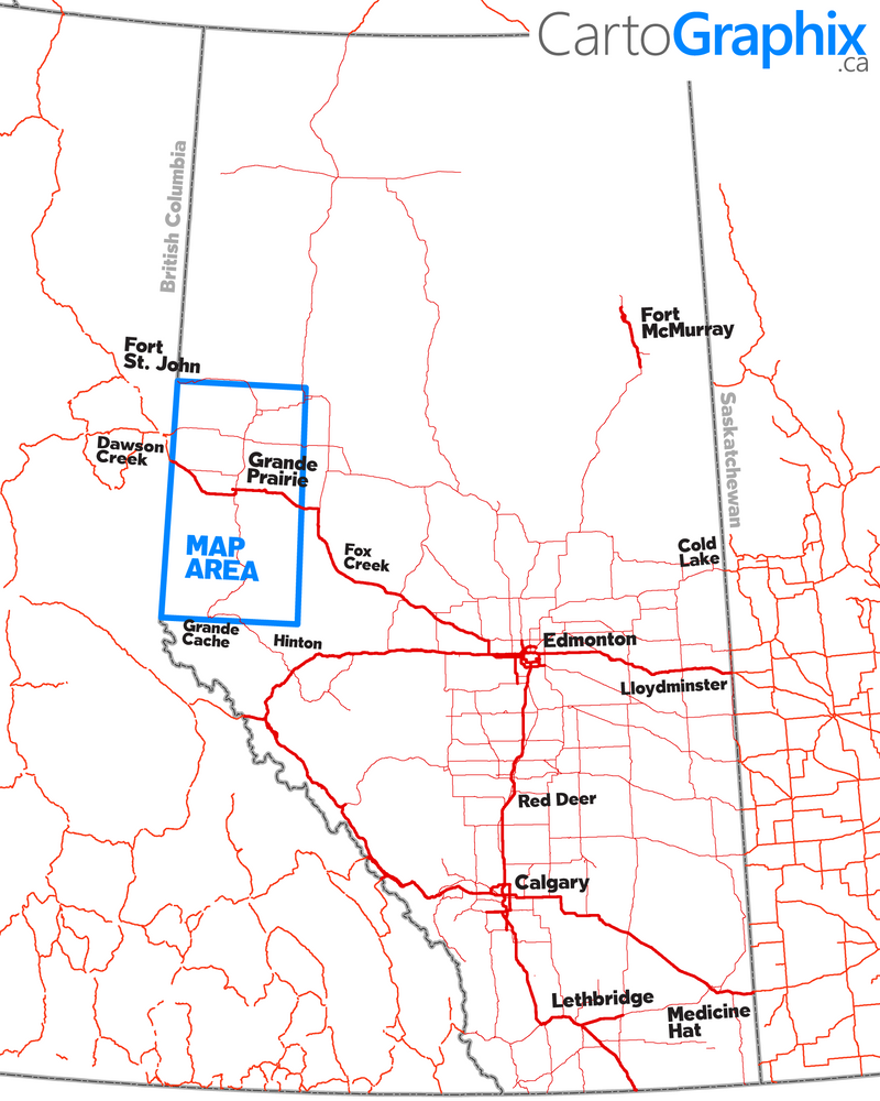
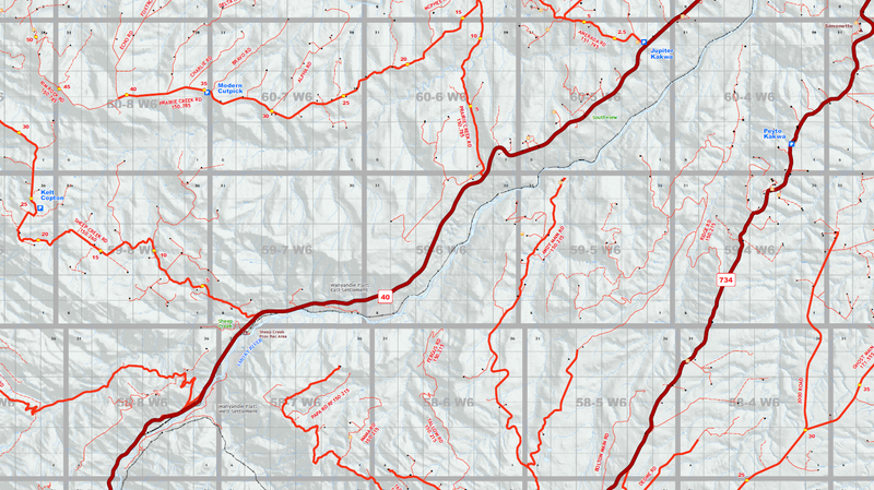
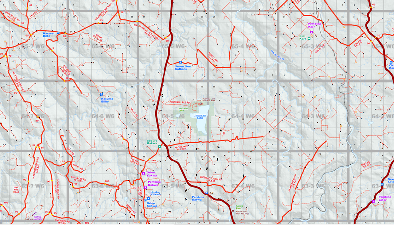
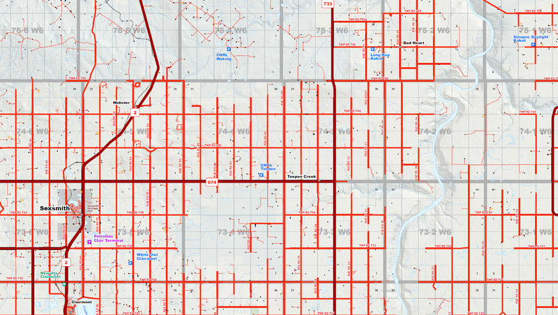
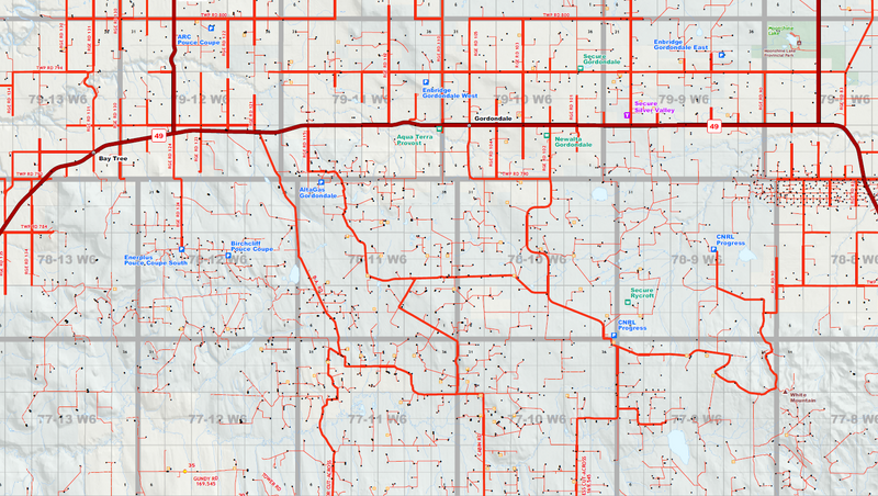
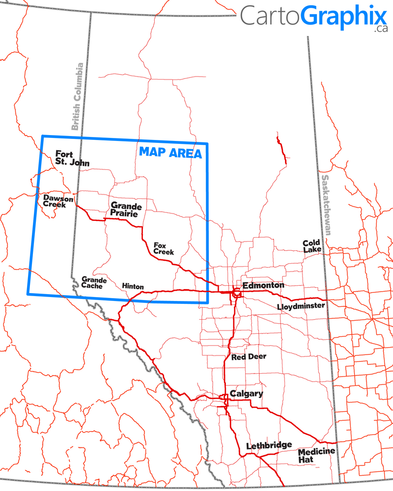
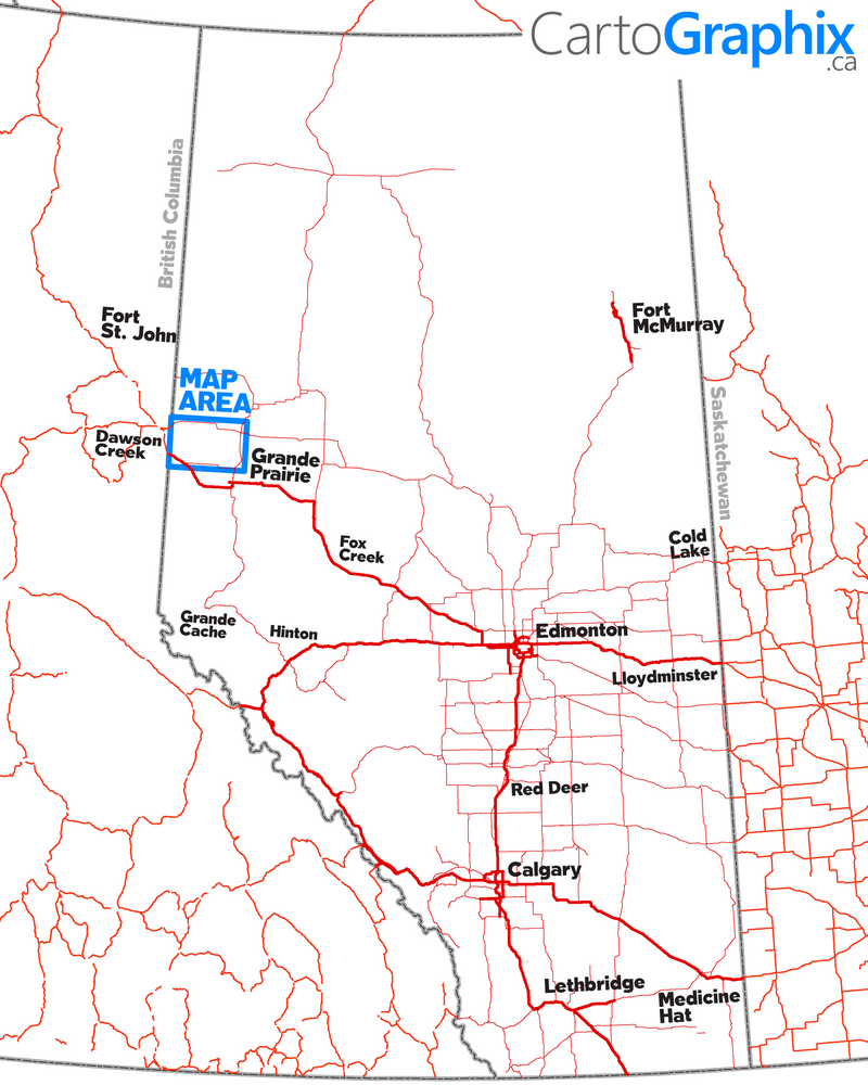
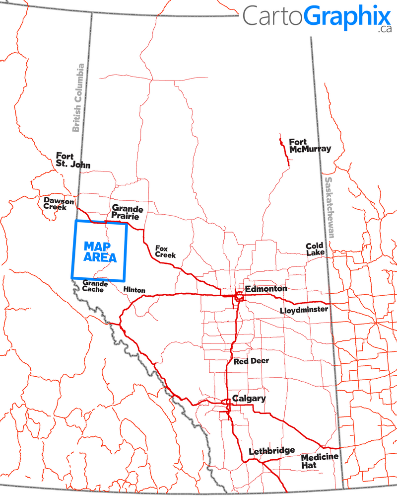
{"id":10329290386,"title":"Grande Prairie Oilfield Wall Map (1:175K) - 36\"W x 63\"H","handle":"grande-prairie-oilfield-wall-map-1-150k-42w-x-74h","description":"\u003ch1\u003e\n\u003cstrong\u003e\u003c\/strong\u003e\u003cspan style=\"color: #0086ff;\"\u003eGrande Prairie Oilfield Wall Map\u003c\/span\u003e\n\u003c\/h1\u003e\n\u003ch3\u003e\u003cspan style=\"color: #999999;\"\u003e\u003cstrong\u003e1:175,000 Scale\u003c\/strong\u003e\u003c\/span\u003e\u003c\/h3\u003e\n\u003cblockquote\u003e\n\u003cdiv style=\"text-align: left;\"\u003e\u003cspan style=\"color: #3d85c6;\"\u003e\u003cstrong\u003e Map Size:\u003c\/strong\u003e\u003c\/span\u003e\u003c\/div\u003e\n\u003cdiv style=\"text-align: left;\"\u003e\u003cspan style=\"color: #666666;\"\u003e\u003cstrong\u003e Width: \u003c\/strong\u003e 36\" \u003c\/span\u003e\u003c\/div\u003e\n\u003cdiv style=\"text-align: left;\"\u003e\u003cspan style=\"color: #666666;\"\u003e\u003cstrong\u003e Height:\u003c\/strong\u003e 63\"\u003c\/span\u003e\u003c\/div\u003e\n\u003c\/blockquote\u003e\n\u003cblockquote\u003e\n\u003cdiv style=\"text-align: left;\"\u003e\u003cspan style=\"color: #3d85c6;\"\u003e\u003cstrong\u003e Map Features:\u003c\/strong\u003e\u003c\/span\u003e\u003c\/div\u003e\n\u003cdiv style=\"text-align: left; padding-left: 30px;\"\u003e\u003cspan style=\"color: #666666;\"\u003ePatchMap™ detailed oilfield roads, with fully named county roads\u003c\/span\u003e\u003c\/div\u003e\n\u003cdiv style=\"text-align: left; padding-left: 30px;\"\u003e\u003cspan style=\"color: #666666;\"\u003eLabeled Gas and Waste Plants\u003c\/span\u003e\u003c\/div\u003e\n\u003cdiv style=\"text-align: left; padding-left: 30px;\"\u003e\u003cspan style=\"color: #666666;\"\u003eCompressor Stations \u003c\/span\u003e\u003c\/div\u003e\n\u003cdiv style=\"text-align: left; padding-left: 30px;\"\u003e\u003cspan style=\"color: #666666;\"\u003eLabeled Township and Section Grid\u003c\/span\u003e\u003c\/div\u003e\n\u003cdiv style=\"text-align: left; padding-left: 30px;\"\u003e\u003cspan style=\"color: #666666;\"\u003eDetailed streams and waterbodies\u003c\/span\u003e\u003c\/div\u003e\n\u003cdiv style=\"text-align: left; padding-left: 30px;\"\u003e\u003cspan style=\"color: #666666;\"\u003eParks and Protected Areas\u003c\/span\u003e\u003c\/div\u003e\n\u003cdiv style=\"text-align: left; padding-left: 30px;\"\u003e\u003cspan style=\"color: #666666;\"\u003eFirst Nations Reserves, Metis Settlements\u003c\/span\u003e\u003c\/div\u003e\n\u003cdiv style=\"text-align: left; padding-left: 30px;\"\u003e\u003cspan style=\"color: #666666;\"\u003eMunicipal Boundaries\u003c\/span\u003e\u003c\/div\u003e\n\u003cdiv style=\"text-align: left; padding-left: 30px;\"\u003e\u003cspan style=\"color: #666666;\"\u003eRelief Shade background\u003c\/span\u003e\u003c\/div\u003e\n\u003c\/blockquote\u003e\n\u003cblockquote\u003e\n\u003cdiv style=\"text-align: left;\"\u003e\u003cspan style=\"color: #3d85c6;\"\u003e\u003cstrong\u003e Map Extents:\u003c\/strong\u003e\u003c\/span\u003e\u003c\/div\u003e\n\u003cdiv style=\"text-align: left;\"\u003e\u003cspan style=\"color: #666666;\"\u003e\u003cstrong\u003e Left: \u003c\/strong\u003e BC\/AB Border (Rge 13 W6) \u003c\/span\u003e\u003c\/div\u003e\n\u003cdiv style=\"text-align: left;\"\u003e\u003cspan style=\"color: #666666;\"\u003e\u003cstrong\u003e Right:\u003c\/strong\u003e Simonette River (Rge 24 W5)\u003c\/span\u003e\u003c\/div\u003e\n\u003cdiv style=\"text-align: left;\"\u003e\u003cspan style=\"color: #666666;\"\u003e\u003cstrong\u003e Bottom:\u003c\/strong\u003e Grande Cache (Twp 55) \u003c\/span\u003e\u003c\/div\u003e\n\u003cdiv style=\"text-align: left;\"\u003e\u003cspan style=\"color: #666666;\"\u003e\u003cstrong\u003e Top:\u003c\/strong\u003e Hines Creek (Twp 84)\u003c\/span\u003e\u003c\/div\u003e\n\u003c\/blockquote\u003e\n\u003ctable width=\"100%\"\u003e\n\u003ctbody\u003e\n\u003ctr\u003e\n\u003ctd style=\"width: 46.4516%; text-align: center;\"\u003e\n\u003cdiv\u003e\u003cmeta charset=\"utf-8\"\u003e\u003c\/div\u003e\n\u003cspan style=\"color: #cc0000;\"\u003ePrinted on \u003cstrong\u003eSuper-High-quality, tear-proof polypropylene\u003c\/strong\u003e 'paper'\u003cb\u003e.\u003c\/b\u003e\u003c\/span\u003e\n\u003c\/td\u003e\n\u003c\/tr\u003e\n\u003c\/tbody\u003e\n\u003c\/table\u003e\n\u003cp style=\"text-align: center;\"\u003e\u003cbr\u003e\u003cspan style=\"color: #999999;\"\u003e\u003cem\u003e Like any of our maps, this map can be customized. \u003cspan style=\"color: #ff0000;\"\u003e\u003ca href=\"https:\/\/www.cartographix.ca\/pages\/contact-us\" style=\"color: #0086ff;\" target=\"_blank\"\u003eContact us\u003c\/a\u003e\u003c\/span\u003e for more info..\u003c\/em\u003e\u003c\/span\u003e\u003c\/p\u003e\n\u003cp\u003e \u003c\/p\u003e","published_at":"2017-08-10T11:36:20-06:00","created_at":"2017-08-10T11:36:55-06:00","vendor":"CartoGraphix","type":"map","tags":["Wall Map"],"price":12995,"price_min":12995,"price_max":12995,"available":true,"price_varies":false,"compare_at_price":null,"compare_at_price_min":0,"compare_at_price_max":0,"compare_at_price_varies":false,"variants":[{"id":40889575762,"title":"Default Title","option1":"Default Title","option2":null,"option3":null,"sku":"","requires_shipping":true,"taxable":true,"featured_image":null,"available":true,"name":"Grande Prairie Oilfield Wall Map (1:175K) - 36\"W x 63\"H","public_title":null,"options":["Default Title"],"price":12995,"weight":0,"compare_at_price":null,"inventory_quantity":0,"inventory_management":null,"inventory_policy":"deny","barcode":"","requires_selling_plan":false,"selling_plan_allocations":[]}],"images":["\/\/www.skybase.ca\/cdn\/shop\/products\/Map1_f2f46c74-e38e-484b-bb11-25148f8918db.png?v=1623151279","\/\/www.skybase.ca\/cdn\/shop\/products\/Grande_Prairie_Wall_Map_4.png?v=1623151279","\/\/www.skybase.ca\/cdn\/shop\/products\/Grande_Prairie_Wall_Map_3.png?v=1623151279","\/\/www.skybase.ca\/cdn\/shop\/products\/Grande_Prairie_Wall_Map_2.png?v=1623151279","\/\/www.skybase.ca\/cdn\/shop\/products\/Grande_Prairie_Wall_Map_1.png?v=1623151279"],"featured_image":"\/\/www.skybase.ca\/cdn\/shop\/products\/Map1_f2f46c74-e38e-484b-bb11-25148f8918db.png?v=1623151279","options":["Title"],"media":[{"alt":null,"id":67154116723,"position":1,"preview_image":{"aspect_ratio":0.8,"height":2083,"width":1667,"src":"\/\/www.skybase.ca\/cdn\/shop\/products\/Map1_f2f46c74-e38e-484b-bb11-25148f8918db.png?v=1623151279"},"aspect_ratio":0.8,"height":2083,"media_type":"image","src":"\/\/www.skybase.ca\/cdn\/shop\/products\/Map1_f2f46c74-e38e-484b-bb11-25148f8918db.png?v=1623151279","width":1667},{"alt":null,"id":6830089207923,"position":2,"preview_image":{"aspect_ratio":1.781,"height":885,"width":1576,"src":"\/\/www.skybase.ca\/cdn\/shop\/products\/Grande_Prairie_Wall_Map_4.png?v=1623151279"},"aspect_ratio":1.781,"height":885,"media_type":"image","src":"\/\/www.skybase.ca\/cdn\/shop\/products\/Grande_Prairie_Wall_Map_4.png?v=1623151279","width":1576},{"alt":null,"id":6830089240691,"position":3,"preview_image":{"aspect_ratio":1.751,"height":899,"width":1574,"src":"\/\/www.skybase.ca\/cdn\/shop\/products\/Grande_Prairie_Wall_Map_3.png?v=1623151279"},"aspect_ratio":1.751,"height":899,"media_type":"image","src":"\/\/www.skybase.ca\/cdn\/shop\/products\/Grande_Prairie_Wall_Map_3.png?v=1623151279","width":1574},{"alt":null,"id":6830089273459,"position":4,"preview_image":{"aspect_ratio":1.774,"height":891,"width":1581,"src":"\/\/www.skybase.ca\/cdn\/shop\/products\/Grande_Prairie_Wall_Map_2.png?v=1623151279"},"aspect_ratio":1.774,"height":891,"media_type":"image","src":"\/\/www.skybase.ca\/cdn\/shop\/products\/Grande_Prairie_Wall_Map_2.png?v=1623151279","width":1581},{"alt":null,"id":6830089306227,"position":5,"preview_image":{"aspect_ratio":1.772,"height":893,"width":1582,"src":"\/\/www.skybase.ca\/cdn\/shop\/products\/Grande_Prairie_Wall_Map_1.png?v=1623151279"},"aspect_ratio":1.772,"height":893,"media_type":"image","src":"\/\/www.skybase.ca\/cdn\/shop\/products\/Grande_Prairie_Wall_Map_1.png?v=1623151279","width":1582}],"requires_selling_plan":false,"selling_plan_groups":[],"content":"\u003ch1\u003e\n\u003cstrong\u003e\u003c\/strong\u003e\u003cspan style=\"color: #0086ff;\"\u003eGrande Prairie Oilfield Wall Map\u003c\/span\u003e\n\u003c\/h1\u003e\n\u003ch3\u003e\u003cspan style=\"color: #999999;\"\u003e\u003cstrong\u003e1:175,000 Scale\u003c\/strong\u003e\u003c\/span\u003e\u003c\/h3\u003e\n\u003cblockquote\u003e\n\u003cdiv style=\"text-align: left;\"\u003e\u003cspan style=\"color: #3d85c6;\"\u003e\u003cstrong\u003e Map Size:\u003c\/strong\u003e\u003c\/span\u003e\u003c\/div\u003e\n\u003cdiv style=\"text-align: left;\"\u003e\u003cspan style=\"color: #666666;\"\u003e\u003cstrong\u003e Width: \u003c\/strong\u003e 36\" \u003c\/span\u003e\u003c\/div\u003e\n\u003cdiv style=\"text-align: left;\"\u003e\u003cspan style=\"color: #666666;\"\u003e\u003cstrong\u003e Height:\u003c\/strong\u003e 63\"\u003c\/span\u003e\u003c\/div\u003e\n\u003c\/blockquote\u003e\n\u003cblockquote\u003e\n\u003cdiv style=\"text-align: left;\"\u003e\u003cspan style=\"color: #3d85c6;\"\u003e\u003cstrong\u003e Map Features:\u003c\/strong\u003e\u003c\/span\u003e\u003c\/div\u003e\n\u003cdiv style=\"text-align: left; padding-left: 30px;\"\u003e\u003cspan style=\"color: #666666;\"\u003ePatchMap™ detailed oilfield roads, with fully named county roads\u003c\/span\u003e\u003c\/div\u003e\n\u003cdiv style=\"text-align: left; padding-left: 30px;\"\u003e\u003cspan style=\"color: #666666;\"\u003eLabeled Gas and Waste Plants\u003c\/span\u003e\u003c\/div\u003e\n\u003cdiv style=\"text-align: left; padding-left: 30px;\"\u003e\u003cspan style=\"color: #666666;\"\u003eCompressor Stations \u003c\/span\u003e\u003c\/div\u003e\n\u003cdiv style=\"text-align: left; padding-left: 30px;\"\u003e\u003cspan style=\"color: #666666;\"\u003eLabeled Township and Section Grid\u003c\/span\u003e\u003c\/div\u003e\n\u003cdiv style=\"text-align: left; padding-left: 30px;\"\u003e\u003cspan style=\"color: #666666;\"\u003eDetailed streams and waterbodies\u003c\/span\u003e\u003c\/div\u003e\n\u003cdiv style=\"text-align: left; padding-left: 30px;\"\u003e\u003cspan style=\"color: #666666;\"\u003eParks and Protected Areas\u003c\/span\u003e\u003c\/div\u003e\n\u003cdiv style=\"text-align: left; padding-left: 30px;\"\u003e\u003cspan style=\"color: #666666;\"\u003eFirst Nations Reserves, Metis Settlements\u003c\/span\u003e\u003c\/div\u003e\n\u003cdiv style=\"text-align: left; padding-left: 30px;\"\u003e\u003cspan style=\"color: #666666;\"\u003eMunicipal Boundaries\u003c\/span\u003e\u003c\/div\u003e\n\u003cdiv style=\"text-align: left; padding-left: 30px;\"\u003e\u003cspan style=\"color: #666666;\"\u003eRelief Shade background\u003c\/span\u003e\u003c\/div\u003e\n\u003c\/blockquote\u003e\n\u003cblockquote\u003e\n\u003cdiv style=\"text-align: left;\"\u003e\u003cspan style=\"color: #3d85c6;\"\u003e\u003cstrong\u003e Map Extents:\u003c\/strong\u003e\u003c\/span\u003e\u003c\/div\u003e\n\u003cdiv style=\"text-align: left;\"\u003e\u003cspan style=\"color: #666666;\"\u003e\u003cstrong\u003e Left: \u003c\/strong\u003e BC\/AB Border (Rge 13 W6) \u003c\/span\u003e\u003c\/div\u003e\n\u003cdiv style=\"text-align: left;\"\u003e\u003cspan style=\"color: #666666;\"\u003e\u003cstrong\u003e Right:\u003c\/strong\u003e Simonette River (Rge 24 W5)\u003c\/span\u003e\u003c\/div\u003e\n\u003cdiv style=\"text-align: left;\"\u003e\u003cspan style=\"color: #666666;\"\u003e\u003cstrong\u003e Bottom:\u003c\/strong\u003e Grande Cache (Twp 55) \u003c\/span\u003e\u003c\/div\u003e\n\u003cdiv style=\"text-align: left;\"\u003e\u003cspan style=\"color: #666666;\"\u003e\u003cstrong\u003e Top:\u003c\/strong\u003e Hines Creek (Twp 84)\u003c\/span\u003e\u003c\/div\u003e\n\u003c\/blockquote\u003e\n\u003ctable width=\"100%\"\u003e\n\u003ctbody\u003e\n\u003ctr\u003e\n\u003ctd style=\"width: 46.4516%; text-align: center;\"\u003e\n\u003cdiv\u003e\u003cmeta charset=\"utf-8\"\u003e\u003c\/div\u003e\n\u003cspan style=\"color: #cc0000;\"\u003ePrinted on \u003cstrong\u003eSuper-High-quality, tear-proof polypropylene\u003c\/strong\u003e 'paper'\u003cb\u003e.\u003c\/b\u003e\u003c\/span\u003e\n\u003c\/td\u003e\n\u003c\/tr\u003e\n\u003c\/tbody\u003e\n\u003c\/table\u003e\n\u003cp style=\"text-align: center;\"\u003e\u003cbr\u003e\u003cspan style=\"color: #999999;\"\u003e\u003cem\u003e Like any of our maps, this map can be customized. \u003cspan style=\"color: #ff0000;\"\u003e\u003ca href=\"https:\/\/www.cartographix.ca\/pages\/contact-us\" style=\"color: #0086ff;\" target=\"_blank\"\u003eContact us\u003c\/a\u003e\u003c\/span\u003e for more info..\u003c\/em\u003e\u003c\/span\u003e\u003c\/p\u003e\n\u003cp\u003e \u003c\/p\u003e"}

