
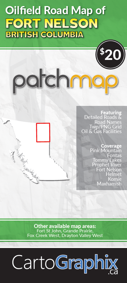
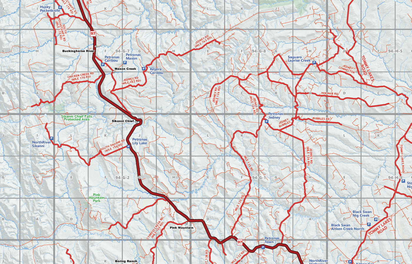
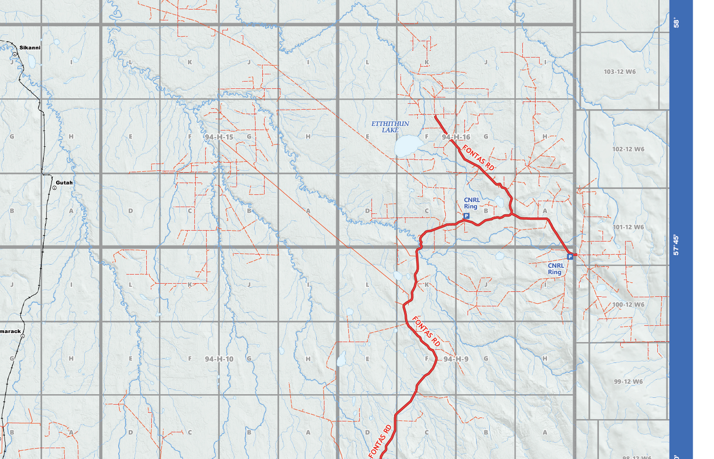
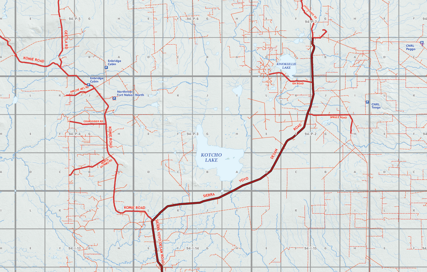
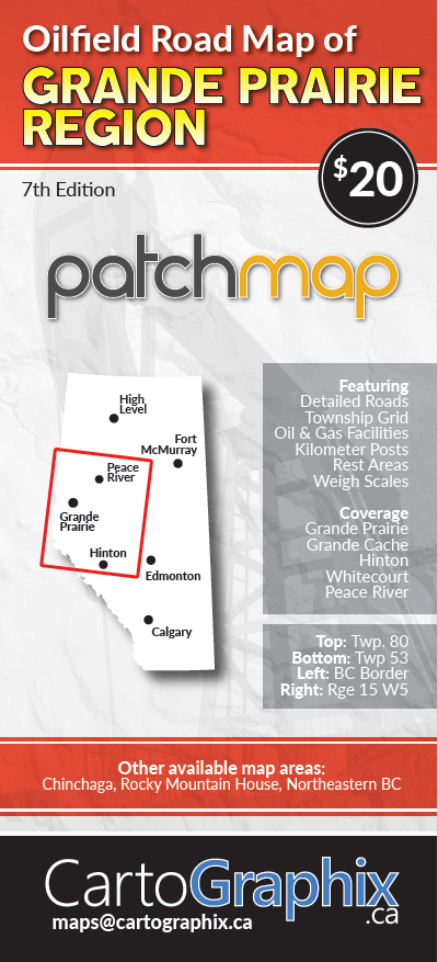
{"id":7088132718790,"title":"Fort Nelson Oilfield Road Map (Folded) - 4\"W x 9\"H","handle":"fort-nelson-oilfield-road-map-folded-4w-x-9h","description":"\u003cp\u003eFeatures accurate PatchMap™ oilfield roads, labeled gas and waste plants, wellsites, compressor stations, township grid with sections, PNG grid, detailed streams and waterbodies, parks and protected areas, First Nations reserves\/ Metis settlements, and relief-shade background.\u003c\/p\u003e\n\u003cdiv\u003e\u003cspan\u003e\u003cstrong\u003e Map Extents:\u003c\/strong\u003e\u003c\/span\u003e\u003c\/div\u003e\n\u003cdiv\u003e\u003cspan\u003e\u003cstrong\u003e Left: \u003c\/strong\u003e Maxhamish Lake (-124°)\u003c\/span\u003e\u003c\/div\u003e\n\u003cdiv\u003e\u003cspan\u003e\u003cstrong\u003e Right:\u003c\/strong\u003e BC\/AB Border (-120°)\u003c\/span\u003e\u003c\/div\u003e\n\u003cdiv\u003e\u003cspan\u003e\u003cstrong\u003e Bottom:\u003c\/strong\u003e Pink Mountain (57°)\u003c\/span\u003e\u003c\/div\u003e\n\u003cdiv\u003e\u003cspan\u003e\u003cstrong\u003e Top:\u003c\/strong\u003e BC\/NWT Border (60°)\u003c\/span\u003e\u003c\/div\u003e\n\u003cp\u003e \u003c\/p\u003e\n\u003cdiv\u003e\u003cspan\u003e\u003cstrong\u003e Folded Size:\u003c\/strong\u003e 4\"W x 9\"H\u003c\/span\u003e\u003c\/div\u003e\n\u003cdiv\u003e\u003cspan\u003e\u003cstrong\u003e Unfolded Size:\u003c\/strong\u003e 39\"W x 27\"H\u003c\/span\u003e\u003c\/div\u003e\n\u003cdiv\u003e\n\u003cspan\u003e\u003c\/span\u003e\u003cbr\u003e\n\u003c\/div\u003e\n\u003cdiv\u003e\n\u003cspan\u003e\u003c\/span\u003e\u003cbr\u003e\n\u003c\/div\u003e\n\u003cdiv\u003e\u003cspan\u003eThis is a single-sided map, printed on high quality paper\u003c\/span\u003e\u003c\/div\u003e\n\u003cp\u003e\u003cbr\u003e\u003cspan\u003eManufacturer: \u003cb\u003eCartoGraphix\u003c\/b\u003e\u003c\/span\u003e\u003c\/p\u003e","published_at":"2021-11-16T08:02:00-07:00","created_at":"2021-11-16T08:02:00-07:00","vendor":"CartoGraphix","type":"map","tags":[],"price":2000,"price_min":2000,"price_max":2000,"available":true,"price_varies":false,"compare_at_price":null,"compare_at_price_min":0,"compare_at_price_max":0,"compare_at_price_varies":false,"variants":[{"id":41232616784070,"title":"Default Title","option1":"Default Title","option2":null,"option3":null,"sku":"","requires_shipping":true,"taxable":true,"featured_image":null,"available":true,"name":"Fort Nelson Oilfield Road Map (Folded) - 4\"W x 9\"H","public_title":null,"options":["Default Title"],"price":2000,"weight":0,"compare_at_price":null,"inventory_quantity":-4,"inventory_management":null,"inventory_policy":"deny","barcode":"","requires_selling_plan":false,"selling_plan_allocations":[]}],"images":["\/\/www.skybase.ca\/cdn\/shop\/products\/BCFN_Cover.png?v=1637075143","\/\/www.skybase.ca\/cdn\/shop\/products\/FN1.png?v=1637075271","\/\/www.skybase.ca\/cdn\/shop\/products\/FN2.png?v=1637075271","\/\/www.skybase.ca\/cdn\/shop\/products\/FN3.png?v=1637075271"],"featured_image":"\/\/www.skybase.ca\/cdn\/shop\/products\/BCFN_Cover.png?v=1637075143","options":["Title"],"media":[{"alt":null,"id":24162463219910,"position":1,"preview_image":{"aspect_ratio":0.449,"height":978,"width":439,"src":"\/\/www.skybase.ca\/cdn\/shop\/products\/BCFN_Cover.png?v=1637075143"},"aspect_ratio":0.449,"height":978,"media_type":"image","src":"\/\/www.skybase.ca\/cdn\/shop\/products\/BCFN_Cover.png?v=1637075143","width":439},{"alt":null,"id":24162495267014,"position":2,"preview_image":{"aspect_ratio":1.563,"height":1010,"width":1579,"src":"\/\/www.skybase.ca\/cdn\/shop\/products\/FN1.png?v=1637075271"},"aspect_ratio":1.563,"height":1010,"media_type":"image","src":"\/\/www.skybase.ca\/cdn\/shop\/products\/FN1.png?v=1637075271","width":1579},{"alt":null,"id":24162495299782,"position":3,"preview_image":{"aspect_ratio":1.556,"height":1013,"width":1576,"src":"\/\/www.skybase.ca\/cdn\/shop\/products\/FN2.png?v=1637075271"},"aspect_ratio":1.556,"height":1013,"media_type":"image","src":"\/\/www.skybase.ca\/cdn\/shop\/products\/FN2.png?v=1637075271","width":1576},{"alt":null,"id":24162495332550,"position":4,"preview_image":{"aspect_ratio":1.568,"height":1006,"width":1577,"src":"\/\/www.skybase.ca\/cdn\/shop\/products\/FN3.png?v=1637075271"},"aspect_ratio":1.568,"height":1006,"media_type":"image","src":"\/\/www.skybase.ca\/cdn\/shop\/products\/FN3.png?v=1637075271","width":1577}],"requires_selling_plan":false,"selling_plan_groups":[],"content":"\u003cp\u003eFeatures accurate PatchMap™ oilfield roads, labeled gas and waste plants, wellsites, compressor stations, township grid with sections, PNG grid, detailed streams and waterbodies, parks and protected areas, First Nations reserves\/ Metis settlements, and relief-shade background.\u003c\/p\u003e\n\u003cdiv\u003e\u003cspan\u003e\u003cstrong\u003e Map Extents:\u003c\/strong\u003e\u003c\/span\u003e\u003c\/div\u003e\n\u003cdiv\u003e\u003cspan\u003e\u003cstrong\u003e Left: \u003c\/strong\u003e Maxhamish Lake (-124°)\u003c\/span\u003e\u003c\/div\u003e\n\u003cdiv\u003e\u003cspan\u003e\u003cstrong\u003e Right:\u003c\/strong\u003e BC\/AB Border (-120°)\u003c\/span\u003e\u003c\/div\u003e\n\u003cdiv\u003e\u003cspan\u003e\u003cstrong\u003e Bottom:\u003c\/strong\u003e Pink Mountain (57°)\u003c\/span\u003e\u003c\/div\u003e\n\u003cdiv\u003e\u003cspan\u003e\u003cstrong\u003e Top:\u003c\/strong\u003e BC\/NWT Border (60°)\u003c\/span\u003e\u003c\/div\u003e\n\u003cp\u003e \u003c\/p\u003e\n\u003cdiv\u003e\u003cspan\u003e\u003cstrong\u003e Folded Size:\u003c\/strong\u003e 4\"W x 9\"H\u003c\/span\u003e\u003c\/div\u003e\n\u003cdiv\u003e\u003cspan\u003e\u003cstrong\u003e Unfolded Size:\u003c\/strong\u003e 39\"W x 27\"H\u003c\/span\u003e\u003c\/div\u003e\n\u003cdiv\u003e\n\u003cspan\u003e\u003c\/span\u003e\u003cbr\u003e\n\u003c\/div\u003e\n\u003cdiv\u003e\n\u003cspan\u003e\u003c\/span\u003e\u003cbr\u003e\n\u003c\/div\u003e\n\u003cdiv\u003e\u003cspan\u003eThis is a single-sided map, printed on high quality paper\u003c\/span\u003e\u003c\/div\u003e\n\u003cp\u003e\u003cbr\u003e\u003cspan\u003eManufacturer: \u003cb\u003eCartoGraphix\u003c\/b\u003e\u003c\/span\u003e\u003c\/p\u003e"}
Call us at 780-814-2130 to Book a Meeting or Online Demo
780-814-2130 | sales@skybase.ca
Robert Coutts – Founder / CEO
After Hours / Weekends
mobile: 780-518-2666
rc@skybase.ca
Calgary AB - 587.287.1867
Saskatoon SK - 306.500.0995
Victoria BC - 778.402.3967
Keep in Touch
Sign up for our newsletter and be the first to know about coupons and special promotions.
© 2024 Skybase Geomatic Solutions Inc.