
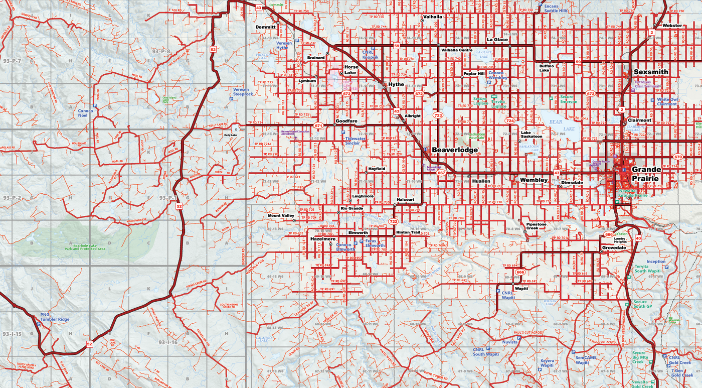
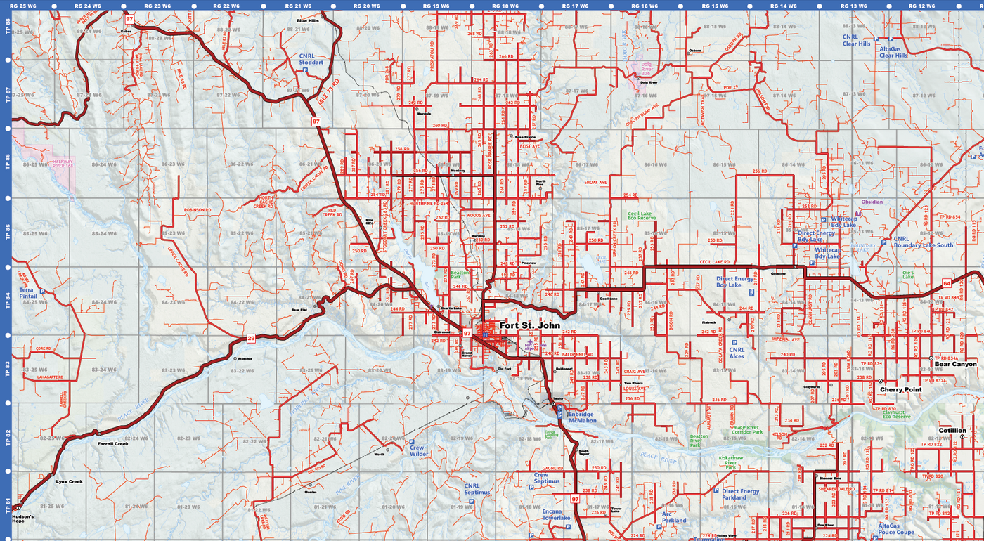
{"id":4558801076339,"title":"Grande Prairie to Fort St John Oilfield Road Map (Folded) - 4\"W x 9\"H","handle":"grande-prairie-to-fort-st-john-oilfield-road-map-folded-4w-x-9h","description":"\u003ch3\u003e\u003cstrong\u003e \u003c\/strong\u003e\u003c\/h3\u003e\n\u003cp\u003eFeatures accurate PatchMap™ oilfield roads, labeled gas and waste plants, township grid, detailed streams and waterbodies, parks and protected areas, First Nations reserves\/ Metis settlements, and relief-shade background.\u003c\/p\u003e\n\u003cdiv\u003e\u003cspan\u003e\u003cstrong\u003e Map Extents:\u003c\/strong\u003e\u003c\/span\u003e\u003c\/div\u003e\n\u003cdiv\u003e\u003cspan\u003e\u003cstrong\u003e Left: \u003c\/strong\u003e Moberly Lake (Rge 25 W6M)\u003c\/span\u003e\u003c\/div\u003e\n\u003cdiv\u003e\u003cspan\u003e\u003cstrong\u003e Right:\u003c\/strong\u003e Teepee Creek (Rge 4 W6M)\u003c\/span\u003e\u003c\/div\u003e\n\u003cdiv\u003e\u003cspan\u003e\u003cstrong\u003e Bottom:\u003c\/strong\u003e Narraway, AB (Twp 63)\u003c\/span\u003e\u003c\/div\u003e\n\u003cdiv\u003e\u003cspan\u003e\u003cstrong\u003e Top:\u003c\/strong\u003e Mile 73 Road, BC (Twp 88)\u003c\/span\u003e\u003c\/div\u003e\n\u003cp\u003e \u003c\/p\u003e\n\u003cdiv\u003e\u003cspan\u003e\u003cstrong\u003e Folded Size:\u003c\/strong\u003e 4\"W x 9\"H\u003c\/span\u003e\u003c\/div\u003e\n\u003cdiv\u003e\u003cspan\u003e\u003cstrong\u003e Unfolded Size:\u003c\/strong\u003e 27\"W x 31\"H\u003c\/span\u003e\u003c\/div\u003e\n\u003cdiv\u003e\n\u003cspan\u003e\u003c\/span\u003e\u003cbr\u003e\n\u003c\/div\u003e\n\u003cdiv\u003e\n\u003cspan\u003e\u003c\/span\u003e\u003cbr\u003e\n\u003c\/div\u003e\n\u003cdiv\u003e\u003cspan\u003eThis is a single-sided map, printed on high quality bond paper\u003c\/span\u003e\u003c\/div\u003e\n\u003cp\u003e\u003cbr\u003e\u003cspan\u003eManufacturer: \u003cb\u003eCartoGraphix\u003c\/b\u003e\u003c\/span\u003e\u003c\/p\u003e\n\u003cp\u003e \u003c\/p\u003e","published_at":"2020-07-27T13:35:47-06:00","created_at":"2020-07-27T13:35:47-06:00","vendor":"CartoGraphix","type":"map","tags":[],"price":2000,"price_min":2000,"price_max":2000,"available":true,"price_varies":false,"compare_at_price":null,"compare_at_price_min":0,"compare_at_price_max":0,"compare_at_price_varies":false,"variants":[{"id":31940837802099,"title":"Default Title","option1":"Default Title","option2":null,"option3":null,"sku":"","requires_shipping":true,"taxable":true,"featured_image":null,"available":true,"name":"Grande Prairie to Fort St John Oilfield Road Map (Folded) - 4\"W x 9\"H","public_title":null,"options":["Default Title"],"price":2000,"weight":0,"compare_at_price":null,"inventory_quantity":-10,"inventory_management":null,"inventory_policy":"deny","barcode":"","requires_selling_plan":false,"selling_plan_allocations":[]}],"images":["\/\/www.skybase.ca\/cdn\/shop\/products\/GP_to_FSJ.png?v=1595878591","\/\/www.skybase.ca\/cdn\/shop\/products\/Grande_Prairie_to_Fort_St_John_Map_1.png?v=1595878591","\/\/www.skybase.ca\/cdn\/shop\/products\/Grande_Prairie_to_Fort_St_John_Map_2.png?v=1595878591"],"featured_image":"\/\/www.skybase.ca\/cdn\/shop\/products\/GP_to_FSJ.png?v=1595878591","options":["Title"],"media":[{"alt":null,"id":7084919849075,"position":1,"preview_image":{"aspect_ratio":0.457,"height":868,"width":397,"src":"\/\/www.skybase.ca\/cdn\/shop\/products\/GP_to_FSJ.png?v=1595878591"},"aspect_ratio":0.457,"height":868,"media_type":"image","src":"\/\/www.skybase.ca\/cdn\/shop\/products\/GP_to_FSJ.png?v=1595878591","width":397},{"alt":null,"id":7084919816307,"position":2,"preview_image":{"aspect_ratio":1.811,"height":1020,"width":1847,"src":"\/\/www.skybase.ca\/cdn\/shop\/products\/Grande_Prairie_to_Fort_St_John_Map_1.png?v=1595878591"},"aspect_ratio":1.811,"height":1020,"media_type":"image","src":"\/\/www.skybase.ca\/cdn\/shop\/products\/Grande_Prairie_to_Fort_St_John_Map_1.png?v=1595878591","width":1847},{"alt":null,"id":7084919881843,"position":3,"preview_image":{"aspect_ratio":1.818,"height":1018,"width":1851,"src":"\/\/www.skybase.ca\/cdn\/shop\/products\/Grande_Prairie_to_Fort_St_John_Map_2.png?v=1595878591"},"aspect_ratio":1.818,"height":1018,"media_type":"image","src":"\/\/www.skybase.ca\/cdn\/shop\/products\/Grande_Prairie_to_Fort_St_John_Map_2.png?v=1595878591","width":1851}],"requires_selling_plan":false,"selling_plan_groups":[],"content":"\u003ch3\u003e\u003cstrong\u003e \u003c\/strong\u003e\u003c\/h3\u003e\n\u003cp\u003eFeatures accurate PatchMap™ oilfield roads, labeled gas and waste plants, township grid, detailed streams and waterbodies, parks and protected areas, First Nations reserves\/ Metis settlements, and relief-shade background.\u003c\/p\u003e\n\u003cdiv\u003e\u003cspan\u003e\u003cstrong\u003e Map Extents:\u003c\/strong\u003e\u003c\/span\u003e\u003c\/div\u003e\n\u003cdiv\u003e\u003cspan\u003e\u003cstrong\u003e Left: \u003c\/strong\u003e Moberly Lake (Rge 25 W6M)\u003c\/span\u003e\u003c\/div\u003e\n\u003cdiv\u003e\u003cspan\u003e\u003cstrong\u003e Right:\u003c\/strong\u003e Teepee Creek (Rge 4 W6M)\u003c\/span\u003e\u003c\/div\u003e\n\u003cdiv\u003e\u003cspan\u003e\u003cstrong\u003e Bottom:\u003c\/strong\u003e Narraway, AB (Twp 63)\u003c\/span\u003e\u003c\/div\u003e\n\u003cdiv\u003e\u003cspan\u003e\u003cstrong\u003e Top:\u003c\/strong\u003e Mile 73 Road, BC (Twp 88)\u003c\/span\u003e\u003c\/div\u003e\n\u003cp\u003e \u003c\/p\u003e\n\u003cdiv\u003e\u003cspan\u003e\u003cstrong\u003e Folded Size:\u003c\/strong\u003e 4\"W x 9\"H\u003c\/span\u003e\u003c\/div\u003e\n\u003cdiv\u003e\u003cspan\u003e\u003cstrong\u003e Unfolded Size:\u003c\/strong\u003e 27\"W x 31\"H\u003c\/span\u003e\u003c\/div\u003e\n\u003cdiv\u003e\n\u003cspan\u003e\u003c\/span\u003e\u003cbr\u003e\n\u003c\/div\u003e\n\u003cdiv\u003e\n\u003cspan\u003e\u003c\/span\u003e\u003cbr\u003e\n\u003c\/div\u003e\n\u003cdiv\u003e\u003cspan\u003eThis is a single-sided map, printed on high quality bond paper\u003c\/span\u003e\u003c\/div\u003e\n\u003cp\u003e\u003cbr\u003e\u003cspan\u003eManufacturer: \u003cb\u003eCartoGraphix\u003c\/b\u003e\u003c\/span\u003e\u003c\/p\u003e\n\u003cp\u003e \u003c\/p\u003e"}

Call us at 780-814-2130 to Book a Meeting or Online Demo
780-814-2130 | sales@skybase.ca
Robert Coutts – Founder / CEO
After Hours / Weekends
mobile: 780-518-2666
rc@skybase.ca
Calgary AB - 587.287.1867
Saskatoon SK - 306.500.0995
Victoria BC - 778.402.3967
Keep in Touch
Sign up for our newsletter and be the first to know about coupons and special promotions.
© 2024 Skybase Geomatic Solutions Inc.